


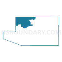
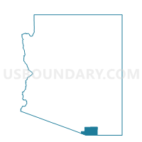
Tubac 11 Voting District, Santa Cruz County, Arizona
About
Outline

Summary
| Unique Area Identifier | 525646 |
| Name | Tubac 11 Voting District |
| County | Santa Cruz County |
| State | Arizona |
| Area (square miles) | 131.10 |
| Land Area (square miles) | 131.03 |
| Water Area (square miles) | 0.07 |
| % of Land Area | 99.94 |
| % of Water Area | 0.06 |
| Latitude of the Internal Point | 31.66598540 |
| Longtitude of the Internal Point | -111.03317420 |
Maps

Graphs
Select a template below for downloading or customizing gragh for Tubac 11 Voting District, Santa Cruz County, Arizona


Neighbors
Neighoring Voting District (by Name) Neighboring Voting District on the Map
- Voting District 139, Pima County, AZ
- Voting District 206, Pima County, AZ
- Voting District 8, Pima County, AZ
- Patagonia 14 Voting District, Santa Cruz County, AZ
- Peck Canyon 21 Voting District, Santa Cruz County, AZ
- Rio Rico 7 Voting District, Santa Cruz County, AZ
Top 10 Neighboring County Subdivision (by Population) Neighboring County Subdivision on the Map
- Tucson CCD, Pima County, AZ (853,603)
- Arivaca CCD, Pima County, AZ (81,534)
- Nogales CCD, Santa Cruz County, AZ (44,207)
- Patagonia CCD, Santa Cruz County, AZ (3,213)
Top 10 Neighboring Place (by Population) Neighboring Place on the Map
- Rio Rico CDP, AZ (18,962)
- Tubac CDP, AZ (1,191)
- Arivaca Junction CDP, AZ (1,090)
- Elephant Head CDP, AZ (612)
- Tumacacori-Carmen CDP, AZ (393)
- Amado CDP, AZ (295)
Top 10 Neighboring Elementary School District (by Population) Neighboring Elementary School District on the Map
- Continental Elementary District, AZ (26,016)
- Sonoita Elementary District, AZ (1,849)
- Patagonia Elementary District, AZ (1,533)
Top 10 Neighboring Secondary School District (by Population) Neighboring Secondary School District on the Map
Top 10 Neighboring Unified School District (by Population) Neighboring Unified School District on the Map
- School District Not Defined, AZ (69,809)
- Sahuarita Unified District, AZ (27,042)
- Santa Cruz Valley Unified District, AZ (20,089)
Top 10 Neighboring State Legislative District Lower Chamber (by Population) Neighboring State Legislative District Lower Chamber on the Map
Top 10 Neighboring State Legislative District Upper Chamber (by Population) Neighboring State Legislative District Upper Chamber on the Map
Top 10 Neighboring 111th Congressional District (by Population) Neighboring 111th Congressional District on the Map
Top 10 Neighboring Census Tract (by Population) Neighboring Census Tract on the Map
- Census Tract 9661.04, Santa Cruz County, AZ (9,945)
- Census Tract 41.07, Pima County, AZ (8,521)
- Census Tract 43.16, Pima County, AZ (3,599)
- Census Tract 9660, Santa Cruz County, AZ (3,213)
- Census Tract 43.24, Pima County, AZ (2,708)
- Census Tract 9661.01, Santa Cruz County, AZ (2,593)
- Census Tract 41.20, Pima County, AZ (852)
Top 10 Neighboring 5-Digit ZIP Code Tabulation Area (by Population) Neighboring 5-Digit ZIP Code Tabulation Area on the Map
- 85614, AZ (21,895)
- 85648, AZ (19,080)
- 85645, AZ (2,231)
- 85624, AZ (1,426)
- 85646, AZ (1,311)
- 85640, AZ (441)